this post was submitted on 04 Sep 2024
853 points (95.9% liked)
Fuck Cars
11167 readers
575 users here now
A place to discuss problems of car centric infrastructure or how it hurts us all. Let's explore the bad world of Cars!
Rules
1. Be Civil
You may not agree on ideas, but please do not be needlessly rude or insulting to other people in this community.
2. No hate speech
Don't discriminate or disparage people on the basis of sex, gender, race, ethnicity, nationality, religion, or sexuality.
3. Don't harass people
Don't follow people you disagree with into multiple threads or into PMs to insult, disparage, or otherwise attack them. And certainly don't doxx any non-public figures.
4. Stay on topic
This community is about cars, their externalities in society, car-dependency, and solutions to these.
5. No reposts
Do not repost content that has already been posted in this community.
Moderator discretion will be used to judge reports with regard to the above rules.
Posting Guidelines
In the absence of a flair system on lemmy yet, let’s try to make it easier to scan through posts by type in here by using tags:
- [meta] for discussions/suggestions about this community itself
- [article] for news articles
- [blog] for any blog-style content
- [video] for video resources
- [academic] for academic studies and sources
- [discussion] for text post questions, rants, and/or discussions
- [meme] for memes
- [image] for any non-meme images
- [misc] for anything that doesn’t fall cleanly into any of the other categories
Recommended communities:
founded 2 years ago
MODERATORS
you are viewing a single comment's thread
view the rest of the comments
view the rest of the comments
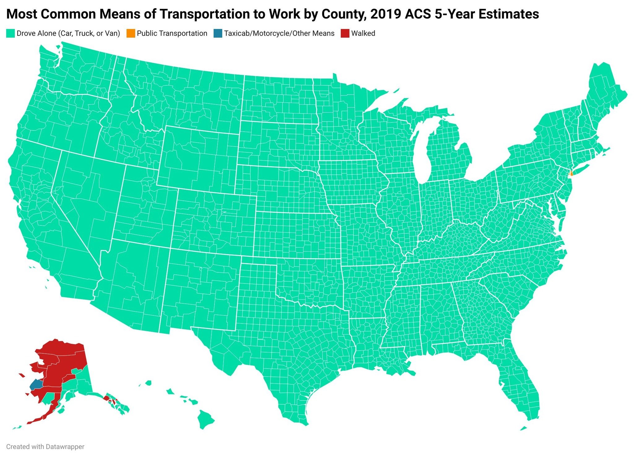
Did San Francisco sink into the bay? It looks like the map didn't include it, shame since that's probably the only place outside NYC that may be a different color.
EDIT:
Looks like someone else noticed it to and did a close up on the original. It shows SF is public transit and also shows that dc is missing on this map as well and also is more public transit then driving, so not just New York. You can also see it by borough in NY and Staten Island is cars but Hudson county NJ is public transit too.
Yeah, while transit exists in SF… it’s not great.
The choice of measurement is a misleading one. We do have a handful of cities with good transit options but this choice of measurement shows them all as green. Many developed countries will show most/all green, not just the US, as if they have the same car culture.
Nope, the map color is correct for San Francisco.
White? There is no San Francisco on the map. There's San Mateo county but the tip of the peninsula where SF city / county should be is just blank.
LOL ok you got me there. I mean driving is the dominant mode in SF.
Depends what you mean by in SF. That is a study of the entire bay area asking how they get to / around SF. That makes sense, most people in the bay area coming into the city are suburbanites who drive in. You'd probably see the same for NYC as well, barring Manhattan which is more or less hostile to driving. People who live in the city though primarily get around by walking transit. The same study says :
So it's the dominant mode for people traveling in / through SF but not for people who live in SF.
In my original comment I put an edit in with a link to the original and SF is orange, along with DC which you can't see on this either.